Mawlersĺ Big Adventure ĺ04:
On the Road - Fort Nelson to Watson Lake
Wednesday, 28 July 2004
|
|||
|
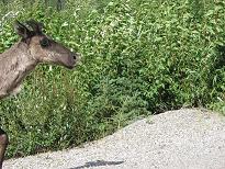
Since we love to get pictures of wildlife, and we are tied to the car for most of the day, it is quite convenient that the animals come right out to the road. We cross a pass that has very pretty views, and I'm concerned that we've passed stone mountain without seeing any sheep. We've been told the night before by an RCMP fellow we meet at dinner that he has seen zillions of sheep on stone mountain. As a matter of fact, he makes it sound like you have to tiptoe through to keep from running the poor things down. So, suffice it to say, when we pass what I am afraid is stone mountain with nothing but spectacular views, I'm devastated. A few miles further down the road, we pass the excellent "x animal on roadway" sign for the sheep. See the picture on the signs page. It has a before and after drawing of a car hitting a sheep. This gives me hope. In addition, the mountains are all grey, and, well, stone, here, so I am starting to get all aflutter that we may still see sheep. We stop to see some lakes and putter along (putter... that's funny), when we crest a hill and... jackpot. 200 cars (ok, maybe it was only 5) stopped in the road, beside the road, by the road, surrounding a little group of about a dozen stone sheep. A little over half are ewes (girls) and the others are lambs (little tiny fellows, and mostly all white). Again, pictures can be seen on the fauna page. We stop, of course, and set to taking pictures this way and that. Stuart notices first that on the cliff across from us, there are about 15 sheep sticking like flies to the cliff wall. There are a few rams over there, along with the ewes and lambs, so we break out the heavy artillery (we have a 500mm telephoto lens) and take a few shots of them. Meanwhile, Stuart follows a mama and baby that are off by themselves until they pose nicely for him. A lone caribou has decided he needs to get into the act, and he tromps down from an immpossibly steep embankment next to the road. Licking the road, he poses for us. It's velvet season for the caribou, and their fur is mottled and dark, and their antlers are little stumps, covered in a velvety covering. The caribou decides that he doesn't like the attention he's garnered, after all, so he makes a break for it.
Later in the day, we see another caribou who conveniently sidles off into the forest while we fumble for the cameras, and finally we see one right smack in the middle of the road, who can levitate (see pictures on fauna page). One of the pictures that I tried to get of the levitating caribou had just his head in the shot, so he looks like he's peaking in, and because of his mottled coat, he looks like he's a bit hung over or strung out. After the wildlife fun, it starts to rain a little bit, and we come to a section of road work where we have to wait for 15 minutes at a... well... a portable traffic light. This stretch of road is having road work done, so they take you through the construction with a "pilot car," which is a teenaged girl with headphones driving a provincial 4x4 erratically among large road graders and dump trucks. We have to wait at the stop light (surreal, I'll tell you) in the middle of nowhere until the girl comes and picks us up and drives ahead of us through the construction to the other end, 15 km later. Very interesting. Once past the pilot car, the weather actually begins to look up, and we pass a hunormous lake called Muncho Lake. (No, I'm not making this up.) There are some interpretive signs along side the road with some pictures about the construction of the highway here. The signs are at the base of an enormous alluvial fan (makes sense, to go with the hunormous lake). Evidently in the spring, the alluvial fan dumps huge (detect a trend?) amounts of water across the road, so they go through and fix/replace it after the floods each year. The signs tell us that this was a pain in the ass in the 40s. (Of course, it's a walk in the park now...) The lake itself it quite pretty and green/blue, the color of most of the glacial lakes in canada (as far as our experience holds out). Think Lake Louise or Morraine Lake. The sun is at the wrong angle for us to get those kinds of pix, but we got some fun ones. Later that day (yes, there's more), we stop at the Liard Hot Springs. These are sulfer springs along the road that are hot -- about 53 degrees celsius at their source. For those of you Celsius challenged (like me) that's 127 degrees fahrenheit. OUCH. Thankfully, it's only about 110-115 degrees in the main pools that people soak in. We go to the upper spring, to avoid the rush, as it were, where the water is 3 meters (about 10 feet) deep. We paddle around until we become red as a fire engine, and then we get out. Perfect timing. I thought the upper spring was hotter, so when we reach the lower spring and Stuart suggests we try that one, I think it will be cooler... a refreshing after-dip. wrong. It was much much hotter. So hot, in fact, that I can't remember ever getting into water that hot, and we had to get in about a foot at a time, so we could get used to it. That's the usual approach for cold water, not for hot... Anyway, on our way out, we ran into a retired couple from Silver Spring and chatted with them for a while. They drove from Silver Spring and went to Prudhoe Bay. Hey! Why aren't we going to Prudhoe Bay!??! I want to go! Anyway, after getting so many mosquito bites on our legs walking out of there that I think I'd be better able to count the blank spaces than the bites, we are on our way. It's getting a little bit late now, but the road is straight and flat. We see a bear or two on the side of the road, and take pictures of one. While trying to stop to take pictures at one point, we turn off on a dirt road to turn around. We missed the picture, but decided to continue on the dirt road. It was a very pretty little side trip, about 20 minutes to go about 5 km, even with Stuart driving (should say somehting about the road...) Once back on the highway, we have one final surprise. Not far from Watson Lake, our destination, there is a herd of Buffalo on the road. Well, I guess their technically Bison, but still. We stop for a while and take pictures of these guys. I always remember a story a friend told me about Bison ramming his car in the Black Hills in South Dakota, so while I'd like to cuddle up with a polar bear, I have a healthy respect for buffalo. They are just BIG critters. When we arrive in Watson Lake, we luckily don't blink and miss it. We find our "hotel" which is a series of cabins around a gravel parking area. Our pass through "town" yields nothing in the way of obvious restaurants or food, and our room has a kitchenette, so we make our first of many raman noodle dinners, and we go to bed. Even we have had enough wildlife for one day. |
|||
|
|
|||
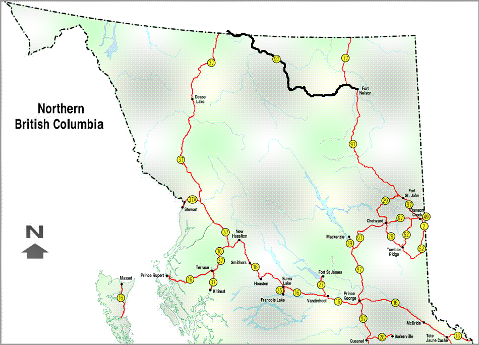 see it on a map |
|||
|
|
|||
|
The previous installment: |
The next installment: |
||
Back to Great White North Trip main page
Back to Mawler Home
All materials © 2004 Lea Ann Mawler & Stuart Mawler