Mawlers’ Big Adventure ’04:
On the Road - Watson Lake to Faro
Thursday, 29 July 2004
|
||||
|
Every book on the Alaska Highway contains a mention of the Sign-Post Forest in Watson Lake. Blah, blah, blah. A few signs up on a few posts. Big deal. Uh, maybe I need to go back and read those books again. They clearly say that there are thousands of signs in the “forest”, so I am not sure what I was expecting. Suffice it to say that there is no way for us to capture any sense of the site in one (or even several) pictures, though we certainly did try. There are signs from all over the world. Apparently, the Alaska Highway is popular with Germans because there are signs from all over Germany. The Sign-Post Forest almost surrounds the Watson Lake Visitor’s Center, so we stopped off there, as well. The center also provides useful road condition information about the Alaska Highway and the Robert Campbell Highway, which is our path toward Faro for today.
At the center, we also receive a new purpose, in case our mission statement regarding some life-changing, yadda-yadda were not enough. It seems that there are several different “games” being sponsored by the Yukon Territorial Government. Each game is a sort of scavenger hunt, requiring people to visit certain towns and collect proof that they visited. The main “game” is the “Yukon Passport”. The passport must be stamped at cultural centers in Watson Lake, Faro, Mayo, Keno, Dawson City, Burwash Landing, Haines Junction, and Whitehorse. The second “game” is the “Yukon Adventure Challenge”. The challenge is to collect the numbers posted on specific landmarks throughout the territory. The challenges are just too much to pass-up! Our plans, which did not include Mayo or Keno, rapidly shift to include those two. Of course, the prize is somewhat compelling; five troy ounces of Yukon gold! In all the excitement, we miss the details about the Yukon Adventure Challenge. One snag: the cultural centers all close by 8 pm. It is about 11 am and we are still in Watson Lake. The lady at the information desk asks where we are going today, so we tell her Faro. She puts some urgency in our travel plans when she asks: “You are not driving all the way to Faro today are you? That is a good 8 hour trip.” Ha.
If we were driving 30 miles in Atlanta, DC, or LA, I could imagine taking 8 hours, but not on a dirt road in Canada. We are somewhat concerned about gas (uh, that’s “petrol” up here). There is nowhere to buy ga… petrol for the next 350+ km. So I decide to take a side-trip. I drive us off on the Nahanni Range Road, also known as the “Cantung Road”. This little road was built by the Canadian Tungsten Corporation to reach their mining camp, which shows up on the map as “Tungsten”. What do you suppose they do there? The road has an obvious commercial nature, but, in case you had any doubt, they include a sign that says “Go away; we don’t want you here; you have no business here. Why are you still sitting there reading this sign? Go away; you’re not welcome!” Ok, so I am paraphrasing, but the message was pretty clear. I don’t really want to take us that far, just down to the river. Besides Lea Ann has this crazy notion that we need to conserve enough gas to make it to Faro. Picky, picky. Fortunately, the river is only about 10 km down the road. The bridge there is fascinating and we take many pictures and come back to the Campbell Highway. Lea Ann spends the whole time calculating fuel consumption rates. The most notable part of the trip from the Nahanni Range Road to Ross River is the fall color. Yup, the beautiful brown, rust orange, and soot black of fall color. Uh wait. Not only are we in a coniferous forest and not yet in fall, but when did “soot black” become a fall color? As it turns out, this is a rough year for forest fires. The sides of the road are smoking in many places. In some areas, there are small patches of actual flame. Of course, we stop for pictures, but not of the open flames. Forest fires are a natural part of the environment and the results are awe inspiring. It is clear that the fires have run right up to and across the road at times. Huge areas are burned. It makes for interesting photography… Finally, we make it to Ross River with some gas to spare. Before filling up, we drive down to the Pelly River and watch the ferry for a few minutes. In addition to the ferry, pedestrians can cross the river on a wooden suspension foot bridge. Of course, I simply must cross this thing.
On the bridge, I really begin to notice the wind. In the middle of the river, the bridge sways as much as three or four feet to either side. Not only that, but the whole thing does a twist with the east end going clockwise and the west end going counter clockwise. Then they switch. It is a bit like a fun house ride. On my way off the bridge, I notice a sign nailed to it. The sign says “Yukon Adventure Challenge” and has a number. I wonder what that means. Could this be some part of a long-distance race, where entrants must run across the bucking bridge? Hmm. Finally getting gas at the only store in town, I ask about the road north of here. Ross River is actually on a side road off the Campbell Highway. This road is the “Canol Road”, named for the Canadian Oil project from World War II. At the same time that we were forcing the Canadians to let us build the Alaska Highway, we coerced them into letting us pump oil out of the Northwest Territories from a place called “Norman Wells”. We built a pumping station at Norman Wells, a pipeline from Norman Wells down through Whitehorse, and a road to follow the pipeline. The whole project cost about USD$135,000,000 in 1942/43. We pumped only 1 million barrels. You do the math. The project was a huge failure and the road was left to wither, the pipes pulled, and the pumping station equipment pulled out of Norman Wells. Today, the Canol Road extends from Whitehorse, through Ross River, and up toward the border with the Northwest Territories. The owner of the gas station says, regarding driving conditions on the North Canol, “You can get pretty close to the border.” From the border to Norman Wells (which is still there and still producing oil, by the way), Canada recognizes the old trace of the road as a “Heritage Trail”. It is not considered drivable in any way. A local (in another town) tells us that it is a rough two-week hike from Norman Wells to the Northwest Territories border. She, a native (in the First Nations sense), adds that the bugs are really, really bad. I can only imagine. From Ross River, we take our full gas tank back on the road, stopping off briefly at the beautiful Lapie Gorge. This is worth a stop, if you are in the area. Most people breeze by, but they miss the deep narrow canyon, graced by extremely blue water. We took pictures. After much more driving, we arrive in Faro and get our Yukon Passports stamped at the visitor’s center. The woman working the desk is like a lot of Canadians in the far north; she has lived and worked everywhere. She is from New Brunswick and has worked in every province except Ontario. She says she liked every town except Inuvik and Old Crow. I guess we will find out about Inuvik for ourselves, but Old Crow is a several hundred km bush plane ride out into the middle of nowhere in northern Yukon. Yes, even up here, there are still places that are farther out in the middle of nowhere. The lady at the visitor’s center sets us up with our accommodations for the evening. She rents us a camping spot in the local campground. We are big spenders tonight; the campground comes in at CDN$2. She then points us to “the restaurant” and “the deli”. She is not kidding. There is almost nothing in this town and most of the houses look deserted. After dinner in “the restaurant”, we go back to our hotel room. That is, we set up the tent. After some adjustment to ensure we are on flat ground, we bed down for the night and listen to the howling of coyotes in the distance. As we fall asleep, it starts to rain. At least we are in the tent, but that means we will be driving with a wet tent spread out in the truck for a few days. |
||||
|
|
||||
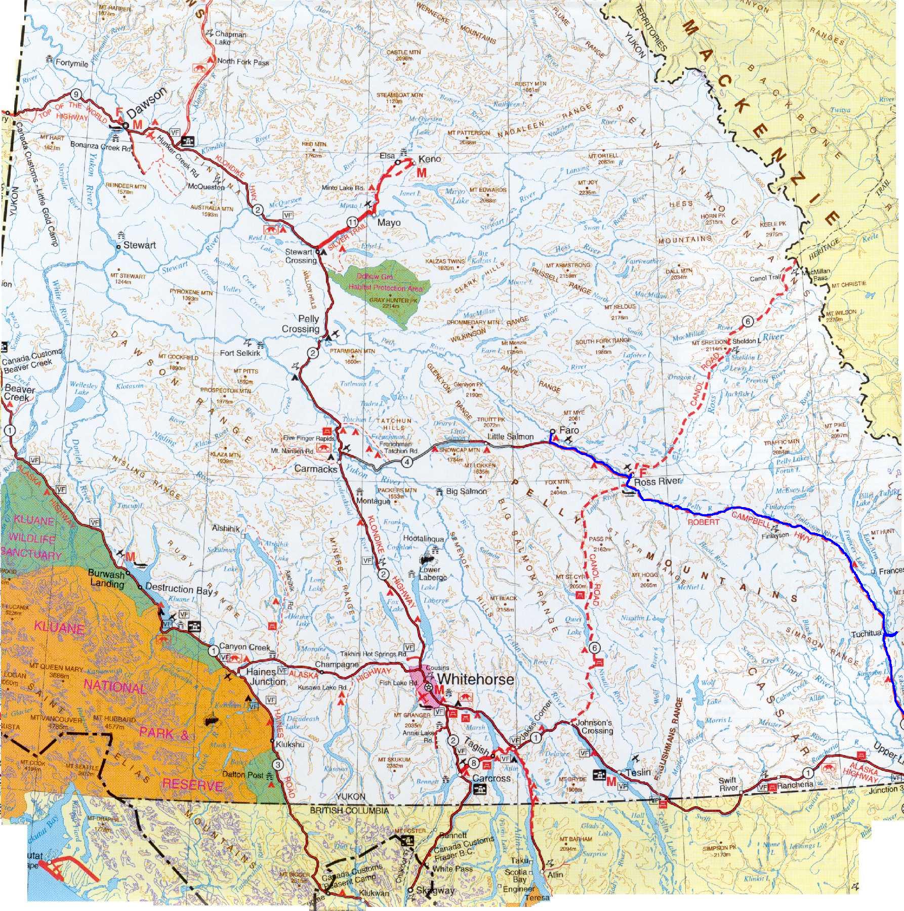 see it on a map |
||||
|
|
||||
|
The previous installment: |
The next installment: |
|||
Back to Great White North Trip main page
Back to Mawler Home
All materials © 2004 Lea Ann Mawler & Stuart Mawler