Mawlersĺ Big Adventure ĺ04:
Stewart to Prince George
Tuesday, 17 August 2004
|
||||||||||
|
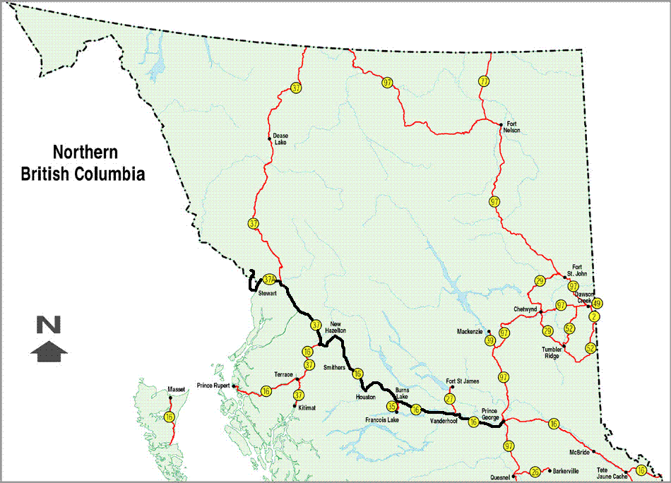
Uncharacteristically, we get an early start. No, really. Would I lie to you? The first item on our agenda is finding out where the one-lane bridge goes. So, we get in the Jeep and get on the bridge and the situation is instantly clear. The bridge extends over the mud flats to a spit of actual land, supporting the townĺs marina.
As it turns out, this is a great place to watch large birds of prey. We see several and are not clear on what they are. They are definitely predators and are very large, but they are colored something like hawks. There is also a lone great blue heron, proving that shore birds have a pretty wide range. Naturally, we take pictures. Satisfied with the bridge adventure, we set out for the last item on the agenda before we get going for Prince George: The Fish Creek Wildlife Viewing Area. In this spot, we have read that you can see grizzlies come to feed on hundreds of spawning salmon. How can we pass up such an opportunity? We figure we can sit at the Viewing Area for a while, see a bear, then get going without losing much time. The Viewing Area is a very well controlled place with fences and Forest Service employees there to keep people and bear separated. It is almost too well organized with parking lots and what not. We park in the second parking lot, which might be considered satellite parking, and walk back to the platform. The path parallels a small creek, where we see several very large salmon swimming up stream. They are amazing to watch because they are huge (for the stream), just sit there in plain sight, and there really are a lot of themŚabout two dozen or so. As we get closer to the viewing platform, the fish small intensifies. And then the source of the smell is clear: the creek on the other side of the platform is jam-packed with salmon, both alive and dead. I assume it is the dead ones who stink. While the two dozen or so fish in the other creek were impressive, this is just incredible. I remember watching salmon spawning as a child in Washington, but nothing like this. No wonder they get so many bear here.
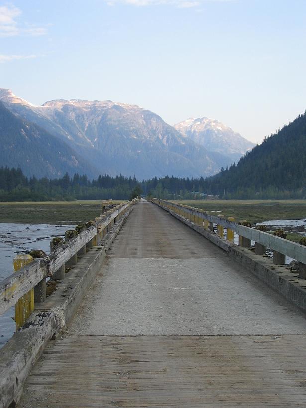
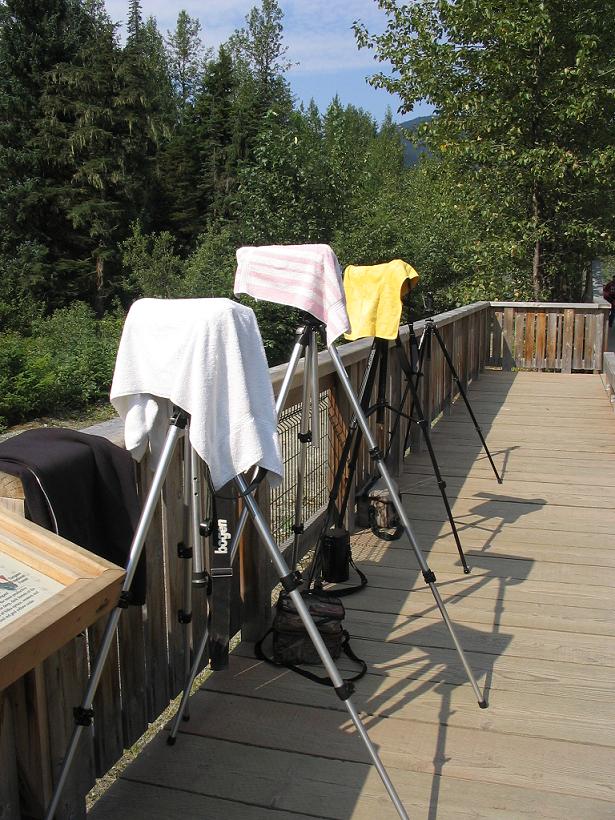
The viewing platform itself is populated mostly by professional photographers. They all have huge tripods, enormous lenses, and egos to match. I am reminded of some strange territorial ritual; the tripods stake the claims made by the male photographers and their lenses are the display to attract attention. We sit for a while with our own cameras, which look pitiful in comparison, watching the light change on the forest around us. Finally, the boredom and the ultra-seriousness of the pros get to us; we just have to get going. Besides, we have been here for about an hour or more and only seen hundreds (or perhaps thousands) of giant salmon and breathed deeply of the smell of rotting salmon corpses, but seen no grizzlies. On our way out, we talk to the Forest Service guy, who identifies the birds of prey that we saw down on the water as juvenile eagles. He then tells us we should go up to the Salmon Glacier for a good view. He says it will take four hours. Ha, we could do it faster. He also adds that "you can take a lunch or whatever because that is Canada and there is no one up there to tell you what to do". It seems the road circles back into Canada, but no one bothers with border patrols considering how incredibly remote everything is. We debate a bit about this side trip because it was not on the itinerary. Did I mention that? Time for another review. We had a plan and reservations to take us north to Inuvik, then we had only a sketchy plan to get us back to Edmonton. The sketchy plan involved a ferry from Haines to Skagway and then the Alaska Highway back to Edmonton. So far, we have ditched the ferry, taken off from the Alaska Highway, added two completely separate highways that were not on the list before, added a side trip to a town not on the list at all, and are now considering what amounts to an entire day-trip up a dirt road to a glacier. And we still need to get back to Edmonton in a few days to return the Jeep. So we set out to see the Salmon Glacier. I drive this part of the route and do so with a vengeance. I am determined not to take too much time on this side trip, since we have places to go. Besides, I figure the road will get worse the farther up we go, so I need to make up some time on the lower portion of the road. As expected, the road conditions quickly go to "sub-optimal". You know those signs that say "road narrows"? Well, they have a few of those on this road, but they have new significance. At the first one, the road narrowed to a pair of wheel ruts, bordered by loose boulders and a sheer drop. The next one was pretty similar. Then they just gave up on signs. We finally arrive at the top and the view of the Salmon Glacier is completely worth it. This is almost as good as a flight over the Kluane Icefields. In fact, it might be better, given the visibility.
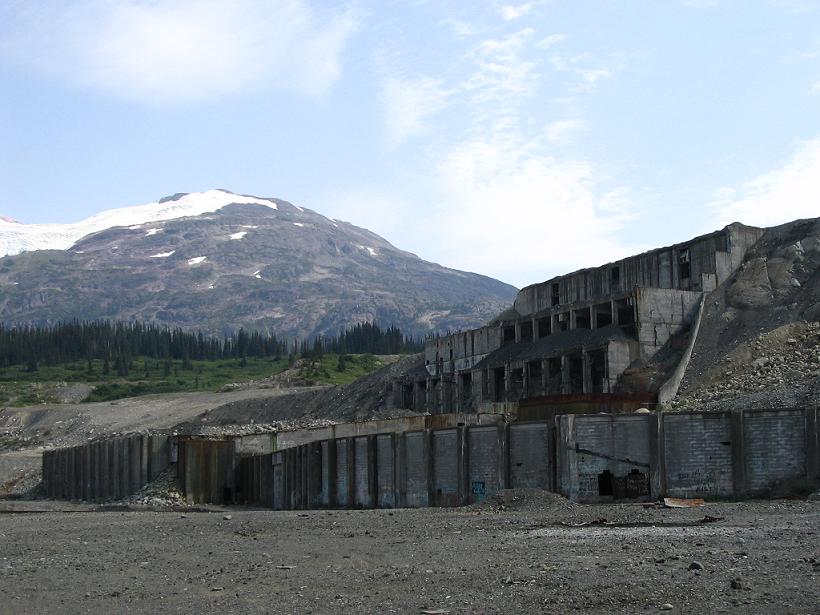
The only drawback is the air force. We have been blissfully unmolested by flying insects, but up here we are attacked with vigor. There are a few other people up here and a couple are actually swearing under their breaths about the bugs. Having taken a whole bunch of interesting pictures, we get back to the car and have some ramen noodles (without multi-tool), while we consider going farther along the road. It is probably the road sign that convinces us to press on. It says "end maintenance". When they say maintenance ends, they really mean it. There were several places where I had to slow to a crawl to keep from bouncing right over the edge into the valley, valley so low. To be fair, they were spreading gravel in a few locations, but overall, it was probably the roughest road of the trip. Driving along one particularly bumpy bit, I am surprised by a gaping whole in the mountain to my right. The hole turns out to be a tunnel entrance with the doors having been forcibly removed from the hinges, so it wide open, practically inviting us to walk into the mountain; so we do. About 100 yards or so into the tunnel, we are a bit concerned and decide to turn around. We have no idea where this goes, for how far, whether there are holes in the floor; nothing. Oddly, the floor is very smooth and without railroad tracks, so it does not seem like a mine shaft. Back at the car, we continue farther up the road, trying to guess if the tunnel comes out the other side. Our powers of deduction are rewarded by the other end of the tunnel. It seems that the road was built through the mountain since they get so much snow up here. In just a couple more kilometers, we come to an overlook, where we can see the remains of a huge mine operation in the valley. This is too much to resist, so we drive down the road to the site.
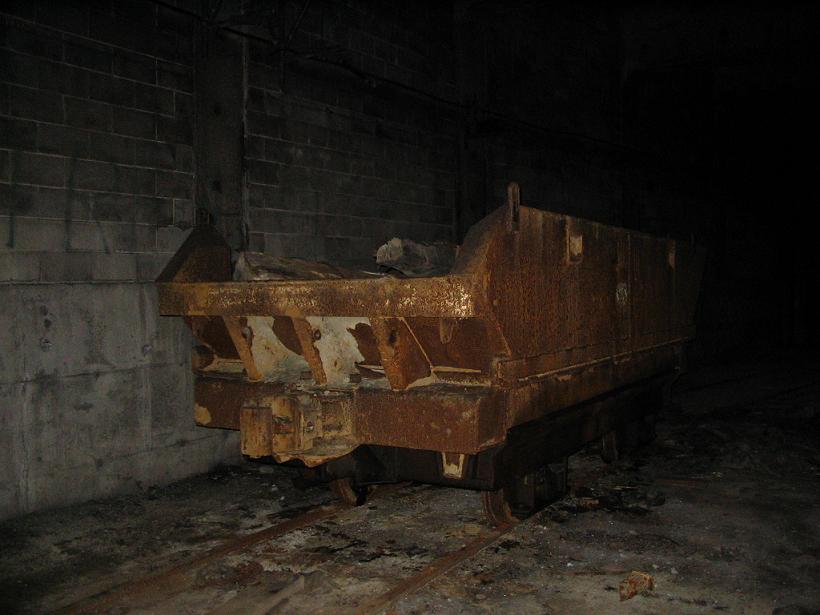
On the way, we pass a family in small sedan (something like an Accord or an Altima). They were headed down to the mine, as well, but have bailed out because the road conditions just got a bit worse. In fact, there are more conditions than road. Once again, we are happy to have a 4x4 with high ground clearance. Down on the site itself, there are two large pickup trucks and the owners are chatting. Leaving Lea Ann to powernap in the Jeep, I head over to find out what they know. It seems one of the guys had a friend who worked this mine. It is the Granduc copper mine, named for the Leduc Glacier that almost makes its way to the entrance. I am always amazed by mining operations. They take vast quantities of capital (I read somewhere that the Granduc took over CDN$150 million to get into production) and yet, at some point, people just walk away. All the equipment is still there, rusting. And the placement of mines is often somewhat ironic. The Granduc is surrounded by some of the most staggeringly beautiful mountain topography in the world. When you look out of the mine, you stare directly into the Leduc Glacier. It is also surrounded by the highest recorded winter snowfall on the planet. So, we pick the most difficult places to build an already difficult business and foul up the most beautiful country in the process. Go figure. Having retrieved valuable intelligence by being nosy with the pickup truck people, I am justly punished. One pickup heads back down to Hyder, leaving one over-exuberant late-middle-age fellow who wants me to take him into the mine with my flashlight. I would rather leap head-long into the mine, thank you, so I spend a great deal of time taking artsy photos outside the mine, until they go away. Obviously, mines are not known for their open, airy, light-filled, ambience. But I often need a refresher on just how dark it is in those places. I do, in fact, have a flashlight, but it runs on AA batteries, so it is essentially useless. I point it at the ground in front of my feet, in hopes that I will avoid falling into any large holes. Small ones are another matter. As a testament to just how dark it is in here, I am shuffling along carefully checking the ground and the air around my head and I almost run into an ore car. This is not one of those tiny things you see in pictures of the coal industry from the mid-1800s. This car is probably more than five feet tall, four feet wide and eight or ten feet long. The thing materialized out of the pitch black. Kinda startled meů I decide to turn back toward the entrance and wake up powernap girl in the Jeep. Together, we take a few pictures of the glacier and then head back toward the mine entrance. She is (sensibly) reluctant to enter the mine, considering that it might not be terribly safe. Instead she tells me to be careful and take good pictures.
A little more aware of what I will find, I shuffle back to the ore car and take a few pictures. The flash is bright enough that I can capture the whole car quite nicely. This gives me an idea. The car is actually on a small siding away from the main shaft, so I turn back to follow the tracks to the main shaft. Once I pass the main entrance again, I pause to take a picture. With the wonders of digital, I get a look at the mine shaft in full color, displayed on my LCD screen. There are no holes of any size on the track bed ahead of me, so I use the flashlight to place my steps and move ahead a few feet. I take another picture and pause to look at the LCD. The floor is still good, but there are now some things hanging from the ceiling. I move ahead again, but with a bit more caution. I take another picture. This time, the LCD shows me a bunch of hanging debris, including wires, insulators, an I-beam. It looks like there has been a fire in this area. I inch forward a bit more and take another picture. I am standing in the pitch black, using the screen on my digital camera to get my bearings in a tunnel that has had obvious damage. This is a bit too creepy, even for me, so I turn around and head back toward the light at the end of the tunnel. (Always wanted to say that.) Lea Ann is happy to see me, so I must be in one piece. Naturally, we are a bit behind schedule, so we bounce back up the road out of the mineĺs valley and then back up to the Salmon Glacier overlook. We try to head back down to Hyder as fast as possible, but there are a few places that require pictures. Arriving back down in Hyder, we realize that the Forest Service guy was wrong about the time for the side trip. He said four hours, but it actually took us five hours. Oops.
Since we have time to spare, we stop back in at the Wildlife Viewing Area to see if there are bear. There are none, but the professional photographers are still strutting around comparing tail feathers, so we get going. It is long since time to get on the road, but we decide to have lunch first. We really had not planned (I know, stop there) to be up on the Salmon Glacier for several hours, so we have not really eaten beyond our daily ration of ramen noodles. As an aside, I should mention that, when traveling in far northwestern Canada, you tend to see the same people over and over again. (Maybe I mentioned this, alreadyů) Here in Stewart, I see a couple from one of the tour groups in Carcross. They were notable as one of the only young couples getting out of the never-ending stream of vans and buses. After nutritious pizza, we pause to get gas and wash the dirt caked windows (this is a theme) and Lea Ann takes the driverĺs seat for the next part of the trip. Basically, we have completed one entire dayĺs worth of travel and are now beginning another. The previous part, while scenic, involved a fair amount of white-knuckle driving over huge boulders, ruts, washboards, etc. along cliff edges. This next portion is a bit less scenic, but is equally white-knuckle, since it is all at high-speed in the dark. Let me emphasize what a feat of driving this is going to be. From the intersection of the Yellow Head and Stewart-Cassiar Highways to Prince George is over 350 km. From the Yellow Head Highway back to the intersection of the Stewart/Hyder Road and the Stewart-Cassiar Highway is 156 km. We are still 60 km down the road in Stewart and it is after 5:00 pm. We are seriously off schedule. Never fear, Lea Ann is here! So, I (Lea Ann) take the wheel in Stewart with my goal getting to Prince George tonight. I donĺt say thisů It seems like a lofty goal, considering that weĺre a long, long way away.
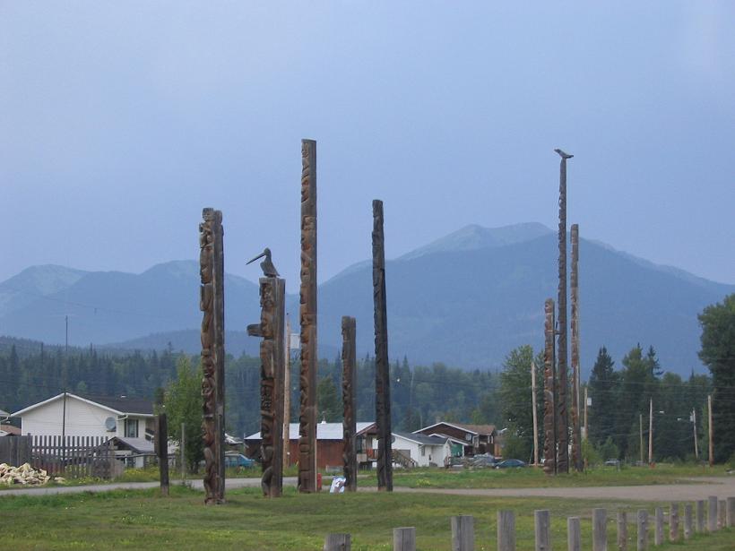
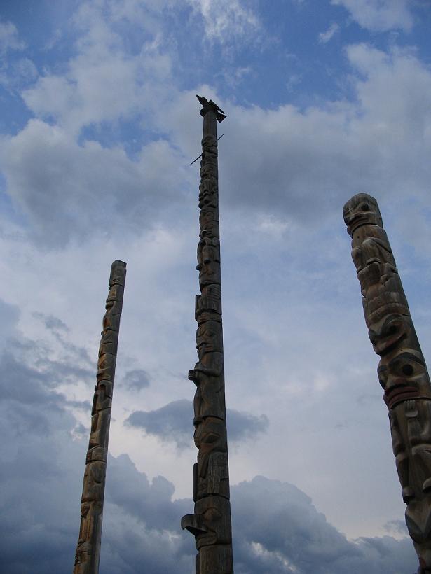
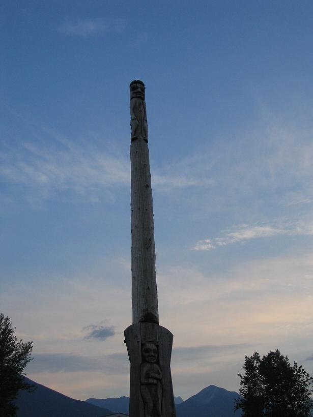
Our first stop (did you really think we wouldnĺt stop?) is to see totem poles in the places along the way that we canĺt pronounce. The first town is Gitanyow, and we turn off the road, not really knowing what we would find. We drive through a small town that feelsů wellů strange. There are tons of people out on the streets, but no one smiles or waves. They look at us as though they donĺt see people from outside of town very often. We get to the town community center and find the totem poles. They arenĺt really very hard to find, being 50 feet tall! The totem poles are of various ages and styles, some with animals that reach off the pole into the air, and some with holes all the way through. We take lots of pictures and wander out of town. A thunderstorm has been chasing us, and weĺve been driving through ╝ mile downpours accompanied by lighting and thunder. While weĺre on our way out of town, we see smoke on the horizon and hope that another lightning-started fire isnĺt its cause.
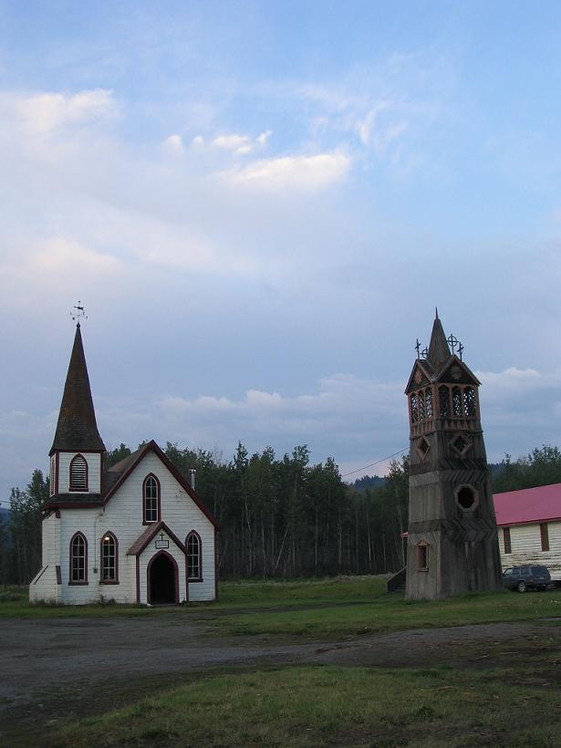
The next town is further down the road, Gitwangak. Itĺs getting dark when we get there, and unlike the previous town, this one has totem poles in peopleĺs yards and along the road. The pictures arenĺt as classic, because of the cars, houses, and power lines that we canĺt avoid. We take some pictures of the church in town, which weĺve spotted in the Milepost. The church, St. Paulĺs Anglican, is a regular little white church with a steeple, but in the front yard, there is a crazy wooden bell tower that we liked. We drive down the road to take a few pictures of the totem poles, and we run into more people who donĺt smile. They have a big dog that chases the truck which makes me very nervous, because Iĺm never sure that dogs will be smart enough not to run under the tires. After a little while, we look at the folks and smile, and surprisingly, they smile widely back. I guess it just takes making the first move! At this point, weĺve lost almost all of our light, and weĺre just getting to the Yellowhead Highway. I drive for a while through construction zones and places where the road narrows to two lanes again. (By the way, this is the main east-west highway in British Columbia.) Not too long after we get moving, Stuart starts to nod off. Although Iĺm the one who traditionally sleeps in the car, Iĺm feeling a bit guilty about us being so far behind schedule because I wanted to see Stewart/Hyder, so I am determined to make it to Prince George. By my calculations, I should be able to make it by midnight, so it shouldnĺt be that badů famous last words. When it gets fully dark, I remember that I have glasses that are several years old. The truth about being profoundly nearsighted is that your brain can compensate for what you canĺt see during the day, but it has a much harder time at night. Lights turn in to bright starbursts, and road lines are very difficult to see. The Yellowhead to Prince George is big and wide and divided when we get on, but quickly it shows its true spirit ľ two-way, narrow, winding, and very hilly. And then, it starts to rain. After a while, there is no one on the road but us and the tractor trailers. Thatĺs good because I donĺt have to worry about oncoming headlights (or oncoming cars), but it also means that I have no taillights to follow and no oneĺs headlights but my own to light the way. The landscape beyond the road is a mystery, and at some point, the gentle rolling hills start to trick me until I canĺt tell whether Iĺm going uphill or down, except for the reading on the tachometer. Somewhere about halfway to Prince George, we go up a steep hill (dare I say mountain?), where the road appears to have been blasted out of the rock. Of course, this could be completely my imagination, considering the darkness, my vision, and the tension of white-knuckled speed-demoning with my navigator asleep.
After a considerable distance of me entertaining myself by calculating the current time, kilometers driven, kilometers to go, and estimated time of arrival at various speeds, we reach a town. I decide that we must get a picture. The town is called Smithers, which is the last name of a friend of ours. Their town welcome sign says, "A town for all Seasons," which is too bad, really, when you consider that they only have a few weeks of summer and all the rest winter up hereů (just kidding.) I get an ice cream cone and gas and we are on our way. Stuart quickly leaves the land of the wakeful again, and stays sacked out except for one more town we drive through where the road makes a 90 degree turn in the middle of town. The jostling always makes his subconscious think Iĺm driving like the crazy-woman he, deep down, knows me to be. J Finally, at about 2 am, we roll into Prince George. My estimates were pretty far off at the beginning of the drive, because of rain and road conditions that didnĺt allow speeds much over 120km/hr. But, I revised as I went, and it turns out that we arrive pretty much when I had become resigned we would. We make a pass through town, find a motel that looks cheap and stop. We should have known when the door was locked, but we figured it was, after all, the middle of the night. The woman at the desk looks at us warily. (I always wonder what others see in our weary, road-worn faces.) She tells us that she wonĺt turn on the phone in the room without a deposit, and that we have to be out by 11. We chuckle and pay her, in advance, of course. |
||||||||||
|
|
||||||||||
 see it on a map |
||||||||||
|
|
||||||||||
|
The previous installment: |
The next installment: |
|||||||||
Back to Great White North Trip main page
Back to Mawler Home
All materials © 2004 Lea Ann Mawler & Stuart Mawler